CLEARWOOD / CLEAR LAKE 150 feet 5G tower PROJECT
New Wireless Tower Project Proposed Near Clearwood and Clear Lake in the Bald Hill Area
A major new wireless communication facility is proposed on Weyerhaeuser timberland near Bald Hill Road SE and Weyerhaeuser Truck Road SE, close to the Clearwood community and Clear Lake, southeast of Yelm.

The current proposal includes an approximately 150-foot monopole with a 5-foot lightning rod, for an overall height of approximately 155 feet, together with a 50-by-50-foot equipment compound, nine AT&T panel antennas, equipment cabinets, a 30-kilowatt diesel backup generator, access improvements, six fiber vaults, and approximately 2,750 feet of utility and fiber trenching.
Known project identifiers include:
Project: 2026101582
Special Use Permit: 26-107217 ZM
SEPA: 26-107218 XA
Parcel: 23505000000
Project name: Yelm Clear Lake
Applicant/site identifiers: WA0091 / OL0750
Carrier: AT&T / New Cingular Wireless PCS, LLC
The project documents also reference J5IP and TowerCo/TowerCo 2013 LLC.
This is a significant project for residents of Clearwood, Clear Lake, Bald Hill Road and the surrounding rural Yelm area, and the public deserves a complete opportunity to review the proposal and participate before a final decision is made.
Thurston County describes new monopoles as Special Use Permit projects generally subject to a Type III process with public notification and a public hearing before the Hearing Examiner.
Why the application deserves careful public review
Community members reviewing the application have identified several issues that deserve careful investigation before the project is approved.
These issues do not by themselves predetermine the outcome of the application. They are reasons why the complete administrative record, environmental analysis and final project design need meaningful public scrutiny.
Wetland and priority bird habitat approximately 275 feet from the tower
The applicant's biological report identifies a freshwater forested and shrub wetland approximately 275 feet north of the proposed tower site.
Of particular importance, the report identifies wood-duck priority habitat associated with this wetland. Additional potentially jurisdictional wetland features have also been identified along portions of the access route where utility trenching and fiber infrastructure are proposed.
Thurston County's wireless ordinance provides that WCFs and associated structures shall not be located within 1,000 feet of wetlands, staging areas or rookeries supporting birds listed as priority species by the Washington Department of Fish and Wildlife, or endangered or threatened birds under federal law.
The relationship between the identified wetland, the documented wood-duck habitat, and this provision of TCC 20.33.040 therefore deserves a clear analysis in the official record.
Critical areas review
The County's review has identified wetlands and hydric soils within 400 feet of the proposal and has required Critical Areas Review covering the development and disturbance area.
That is consistent with the County's current permitting process, under which projects within 400 feet of mapped critical areas can require concurrent Critical Areas Review and biological studies.
Landslide and steep-slope concerns
Another major question concerns the terrain.
County review comments state that the tower may be located within or immediately adjacent to a designated landslide-hazard area. The revised plans appear to place the top of a slope close to or through the proposed tower location, while LiDAR information indicates slopes of 40 percent or greater nearby.
The County has also indicated that antenna-support structures are prohibited within a designated landslide-hazard area and its applicable buffer, potentially raising the question of whether the tower must be relocated or whether the applicant would seek a Reasonable Use Exception.
This needs to be resolved before construction is authorized.
Access road, fiber and utility construction
The tower itself is only part of the project.
The proposal includes approximately 2,750 feet of utility and fiber trenching and six fiber vaults, together with access-road work. Potential wetland features have been identified along portions of this route.
Environmental and critical-area review therefore should address the entire development footprint, rather than only the 50-by-50-foot tower compound.
Changing and inconsistent project documents
Earlier and later versions of the application do not always describe the project in the same manner.
Different documents have described different:
tower heights;
antenna and radio-equipment configurations;
generator specifications;
utility and fiber routes; and
descriptions of whether certain facilities are proposed or already existing.
The revised construction documents have also indicated that some structural and antenna-mount engineering would be submitted separately.
The public should be able to review the actual final configuration that the County intends to approve.
Visual screening on commercial timberland
The application relies substantially on surrounding trees to reduce the visual impact of the tower.
However, this is commercial timberland. Trees that provide screening today may subsequently be harvested.
The County therefore should consider whether the proposed permanent landscaping is sufficient if surrounding commercial timber is removed.
Other questions requiring review
The record also raises questions concerning:
drainage and stormwater;
diesel-fuel storage;
wildlife habitat;
access-road construction;
utility trenching;
structural engineering;
landscaping;
alternative sites;
opportunities for collocation; and
compliance with the County's wireless communication facility ordinance.
We are not asking the community to prejudge the application.
We are asking Thurston County to conduct a complete, transparent and lawful review before irreversible clearing, road construction, trenching, foundation work, utility installation or tower construction occurs.
Help the community obtain qualified legal representation
This application is technically and legally complex.
It involves land-use procedure, SEPA, wetlands, wildlife habitat, steep slopes and landslide hazards, drainage, access construction, utilities, fiber installation, diesel-fuel storage and Thurston County's wireless-facility ordinance.
Local residents are raising funds to retain an experienced Washington land-use attorney who can:
review the complete application and administrative record;
advise residents concerning the applicable County code;
identify deficiencies in the application;
prepare formal written comments and objections;
participate in the public hearing;
examine the applicant's evidence;
address SEPA and critical-area issues;
respond to revised project materials;
preserve administrative and judicial appeal issues; and
protect the community's procedural rights.
Support the Clear Lake / Clearwood fundraiser
Funds are intended for attorney fees, expert consultation, public-hearing preparation, environmental and technical review, public-record expenses, filing and service expenses, and any administrative or judicial appeal that becomes necessary to protect the community's rights.
Community members can also help by:
sharing the fundraiser with neighbors;
registering as an interested person or party of record;
reviewing the project documents;
submitting factual written comments;
attending any public hearing;
reviewing wetlands, wildlife and steep-slope information;
documenting visible conditions from lawful public locations; and
informing neighbors who may not have received mailed notice.
County WCF proceedings have historically provided mailed notice to property owners within approximately 2,600 feet of a project, meaning people outside that radius should not assume they will automatically receive mailed notices.
Register as an interested person and party of record
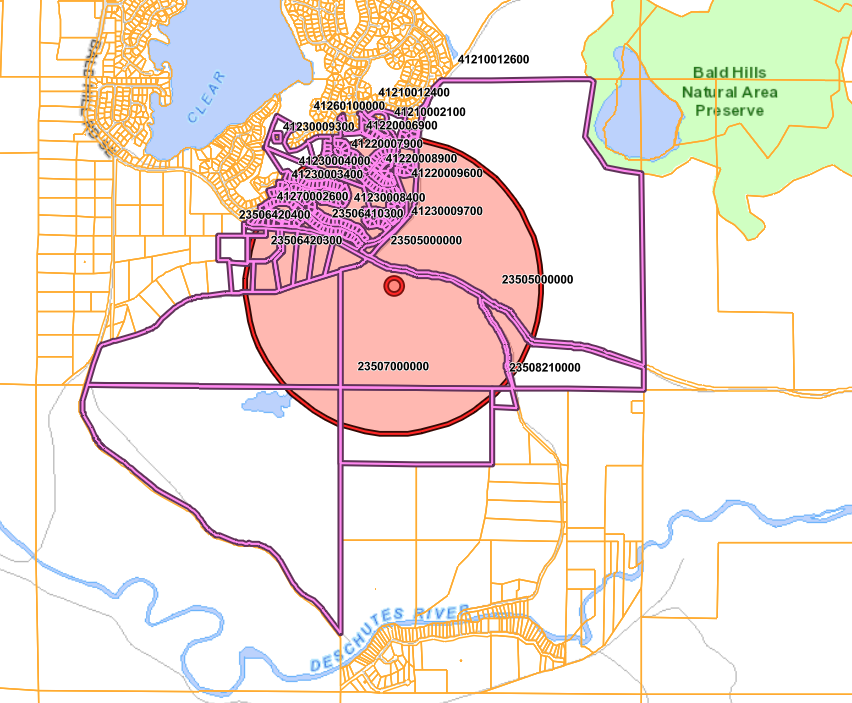
If you live outside the mailed-notification area, outside of the 2600 feet radius above —or simply want to make certain that your contact information is associated with the application (notably if you are a renter as notfication will only be sent to property owners) —send a written request to Thurston County.
The County identifies planning@co.thurston.wa.us as its contact for land-use permits and environmental review.
Suggested email
Subject: Request to be Added as Party of Record — Yelm Clear Lake WCF — Project 2026101582:
Dear Mrs Tschaekofske
I request that I be added immediately as an interested person and party of record for the proposed Yelm Clear Lake wireless communication facility near Bald Hill Road SE and Weyerhaeuser Truck Road SE, Yelm, parcel 23505000000. Known project identifiers include:
Project: 2026101582
Special Use Permit: 26-107217 ZM
SEPA: 26-107218 XA
Parcel: 23505000000
Project: Yelm Clear Lake
Applicant/site identifiers: WA0091 / OL0750
Please: Confirm the current status of each associated application, including whether the application has been determined complete and the date of any completeness or incompleteness determination.
Add my name, email address and mailing address to every interested-person, notification, service, public-comment and party-of-record list associated with this project.
Provide notice and, where available, electronic copies or links whenever any of the following is issued, received, scheduled, revised or posted:
• Notice of Application;
• completeness or incompleteness determination;
• requests for additional information;
• applicant resubmittals or material plan revisions;
• SEPA threshold determination and appeal notice;
• Critical Areas Review determination or approval;
• wetland or wetland-buffer determination;
• landslide-hazard or geotechnical determination;
• any Reasonable Use Exception application or decision;
• clearing, grading, access-road, utility or related permits;
• public hearing notice;
• staff report and attachments;
• agency comments;
• communication matrices;
• Hearing Examiner exhibits, orders and hearing dates;
• final decision;
• reconsideration request or decision; and
• any claimed federal shot-clock extension, tolling agreement, expiration or deemed-granted notice.
Confirm the procedure and deadline for submitting written comments so that they become part of the official administrative record. Confirm that this request itself will be retained in the official project file. This is a request for notice and inclusion on the project's interested-person and party-of-record lists. It is not intended as a standing Public Records Act request for documents that do not yet exist.
My contact information is:
Name: [YOUR NAME]
Mailing address: [YOUR ADDRESS]
Email: [YOUR EMAIL]
Telephone: [YOUR PHONE NUMBER]
Please acknowledge receipt and confirm that I have been added to the appropriate lists. Sincerely,
[YOUR NAME]
How to find the Clearwood / Clear Lake application documents
Thurston County makes permit records available through its public document-search system.
Step 1 — Search the main project number
Enter:
2026101582
Start with the broadest available document category, such as All Documents.
Step 2 — Search the Special Use Permit
Search:
26-107217
or
26-107217 ZM
Step 3 — Search the SEPA application
Search:
26-107218
or
26-107218 XA
Step 4 — Search the parcel
Search:
23505000000
Searching by parcel can reveal additional permits or related records that may not appear when searching only the primary project number.
Learn more about concerns regarding wireless radiation
Environmental, land-use and procedural issues should be raised independently of RF-emission arguments because federal law significantly limits local regulation based on the environmental effects of RF emissions where a facility complies with FCC standards.
For readers who want to review the scientific literature and health concerns collected by our association:
Stay informed. Review the documents. Register for notice. Participate in the public process.


Comments